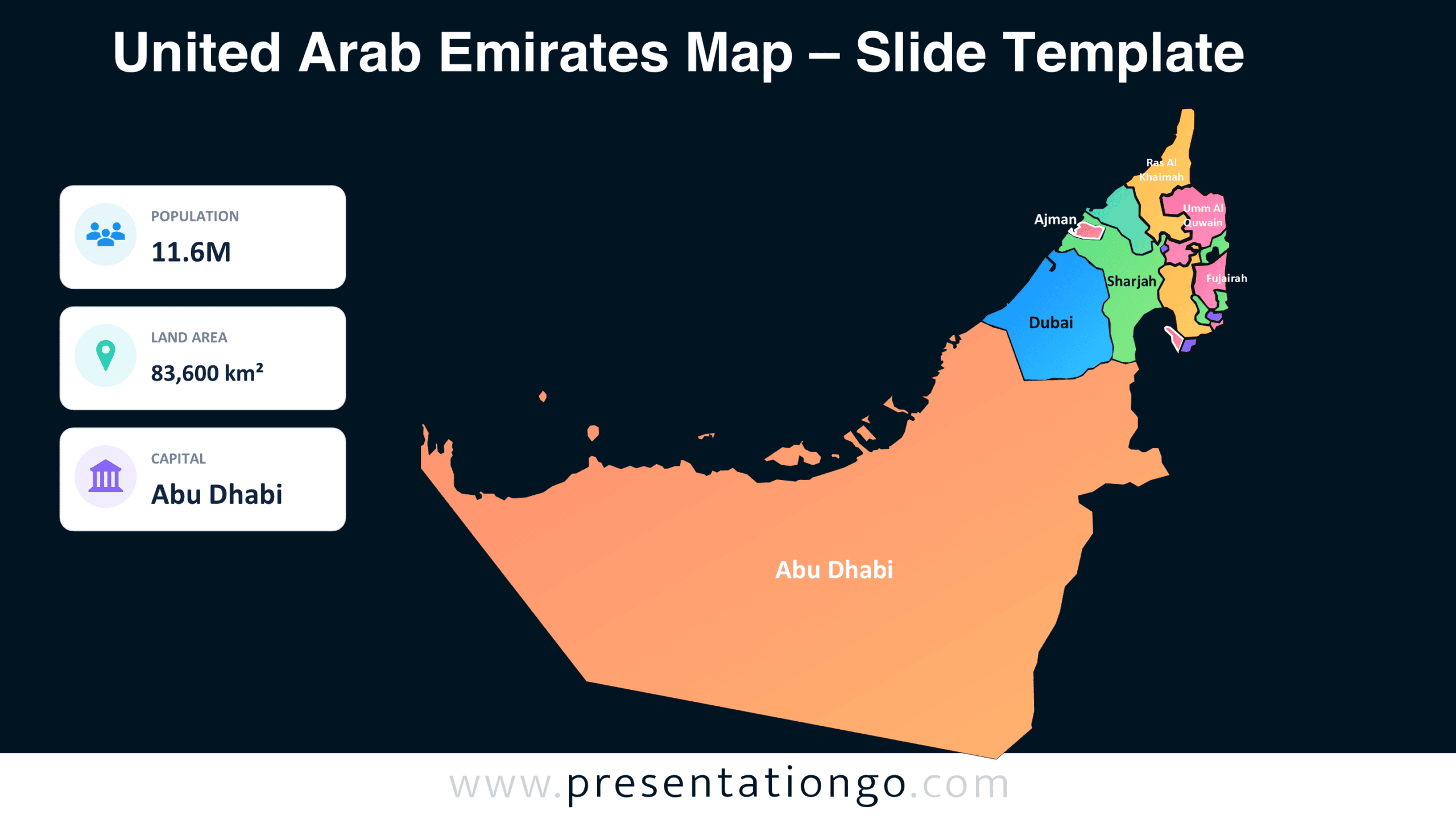
The United Arab Emirates Map is an editable geographic infographic for PowerPoint and Google Slides. It displays the country’s seven emirates with individual regional shapes and labels. Three information cards present population, land area, and capital details. Use this slide to introduce the UAE’s geography and essential national facts.
Diagram Preview
The diagram comes in two slide versions, allowing you to match different presentation styles. Both versions maintain the same geographic layout, labels, and information cards. Preview the design below to examine its structure before downloading.


Features and Customization Options
- Compatible with Microsoft PowerPoint and Google Slides.
- Includes two editable slide versions in 16:9 format.
- Individually selectable vector regions for all seven emirates.
- Editable geographic labels, text, shapes, and information cards.
- Icons shown are for illustration purposes only.
- Icons from the Office library are easily modifiable and replaceable.
- Includes both light and dark background versions.
Design and Structure
The United Arab Emirates Map uses an asymmetrical layout that gives the geographic illustration most of the slide. The country’s outline extends across the central and right sections, emphasizing its distinctive shape and coastal boundaries. Internal divisions distinguish Abu Dhabi, Dubai, Sharjah, Ajman, Umm Al Quwain, Fujairah, and Ras Al Khaimah. Each emirate includes a geographic label, allowing viewers to identify the regions directly. The map uses separate shapes rather than a single flattened picture, supporting regional adjustments.
Three rectangular information cards occupy the left side in a vertical arrangement. Each card combines an icon placeholder, an uppercase category label, and a prominent value. The population card shows 11.6M, while the land area card displays 83,600 km². The capital card identifies Abu Dhabi. Rounded card corners and generous spacing separate these statistics from the larger map illustration. A substantial heading anchors the top of the composition. The layout establishes a consistent reading order between the headline, geographic representation, and supporting country facts.
Practical Applications
- Geography lessons: Teach students the names and relative locations of the seven UAE emirates.
- Country profiles: Introduce the UAE during international studies, diplomatic briefings, or regional presentations.
- Market research: Highlight emirates relevant to expansion plans, customer coverage, or regional operations.
- Tourism presentations: Identify destinations across the UAE when explaining travel routes or visitor regions.
- Corporate briefings: Mark office locations, operating territories, or planned investments within individual emirates.
- Demographic reports: Replace the existing statistics with updated figures from official statistical sources.
- Regional comparisons: Adapt labels and information cards to compare selected emirates within a larger report.
Summary
The United Arab Emirates Map combines an editable regional illustration with a compact overview of national information. Its separate emirate shapes support location-specific content, while the information cards accommodate different reporting needs. Download this PowerPoint and Google Slides infographic to build presentations about UAE geography, regional activity, or country-level research.